News
お知らせ
Responding to surveys in the "MAPRY" Forest Improvement Project
Mapry Co., Ltd. (Headquarters: Tanba City, Hyogo Prefecture, Representative Director: Keiji Yamaguchi, hereinafter referred to as “Mapry”), which has been providing the geospatial information application platform service “MAPRY” useful for forest management and regional activities, is pleased to announce that “MAPRY” has started its official operation as a new survey means corresponding to forest maintenance projects (afforestation subsidy projects).
■Background
In order to demonstrate the multifaceted functions of forests, it is necessary to properly carry out planting, childcare, and thinning, and subsidies for forest maintenance projects are provided for certain tasks for that purpose.
Until now, when applying on the applicant side and the prefectural government inspecting the construction, surveying with a compass etc. at the site was essential, and personnel and time were a heavy burden.
Therefore, Mapry, which is developing applications using iPhone / iPad equipped with LiDAR, by bringing the iPhone / iPad into the forest instead of the compass, so that the measuring person can easily measure the work path etc., so that the measurement person can easily measure the work path etc. so far, We have repeatedly verified the accuracy and improved the function such as the IMU algorithm, but this time, Since we were able to confirm that the results of measurements such as ambient surveying using either IMU (internal sensor of the terminal) or local RTK (RTK correction using mobile stations and reference stations) are within the allowable error by either method, we have decided to officially start providing MAPRY services in the forest maintenance business.
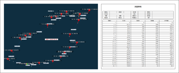
■Accuracy verification
Using MAPRY, we verified the accuracy according to the following applications, and all of the following were within the allowable accuracy of the survey results shown in the example of the internal regulations for completion inspection of afforestation subsidy projects.
(1) Use as a compass survey: Verification of measured azimuth angle, height and low angle errors
(2) Use as GNSS surveying: Verification of errors in measured coordinates
■About Mapry
Mapry is a service for all those involved in surveying, forestry, disaster prevention, agriculture and construction. We provide solutions that can easily acquire and analyze 3D data, which has been difficult to bear the cost of surveying equipment and operate and analyze the equipment.
■Company Profile
Company Name : Mapry Corporation
Location : 165 Tada, Kasuga Town, Tanba-shi, Hyogo Prefecture (Head Office)
Sanyo Rokkaku Building No. 503, 84 Yanagisui-cho, Nakagyo-ku, Kyoto (Kyoto Office)
Representative Director Keiji Yamaguchi
HP : https://mapry.co.jp
Inquiries regarding this matter: info@mapry.co.jp