News
お知らせ
A method for consensus building on forest boundaries using remote sensing and GIS is published
Mapry Inc. (Headquarters: Tamba City, Hyogo Prefecture, CEO: Keiji Yamaguchi, hereinafter referred to as Mapry), which provides the geospatial information app platform service “mapry,” has published a method for consensus building on forest boundaries using remote sensing and GIS on the web media “Forest Tech.”
http://mapry.co.jp/app/wp-content/uploads/2024/04/kyokai_hpeye.jpg
■Background
Many of Japan’s forests are owned in small areas, making forest development difficult. In order to efficiently develop and utilize forests, it is necessary to clarify forest boundaries and consolidate operations.
However, due to the aging of forest owners and problems with the accuracy of official maps, cadastral surveys have not progressed, and the forest boundaries of more than half of the forest land are unclear. In order to efficiently clarify forest boundaries, the Forestry Agency and the Ministry of Land, Infrastructure, Transport and Tourism are supporting surveys using remote sensing and consensus building activities among forest owners.
■Procedure for consensus building on forest boundaries
The process for consensus building on forest boundaries using remote sensing data and GIS can be briefly explained as follows.
1. Planning and preparation
2. Searching for and informing owners
3. Creating a boundary estimate using GIS and remote sensing
4. Creating a forest boundary proposal (checking with local experts)
5. Confirming forest boundaries with the consent of forest owners
Of these, by using our WebGIS and remote sensing equipment for the creation of the boundary estimate in 3. and the formation of a consensus in 5., the work can be carried out efficiently.
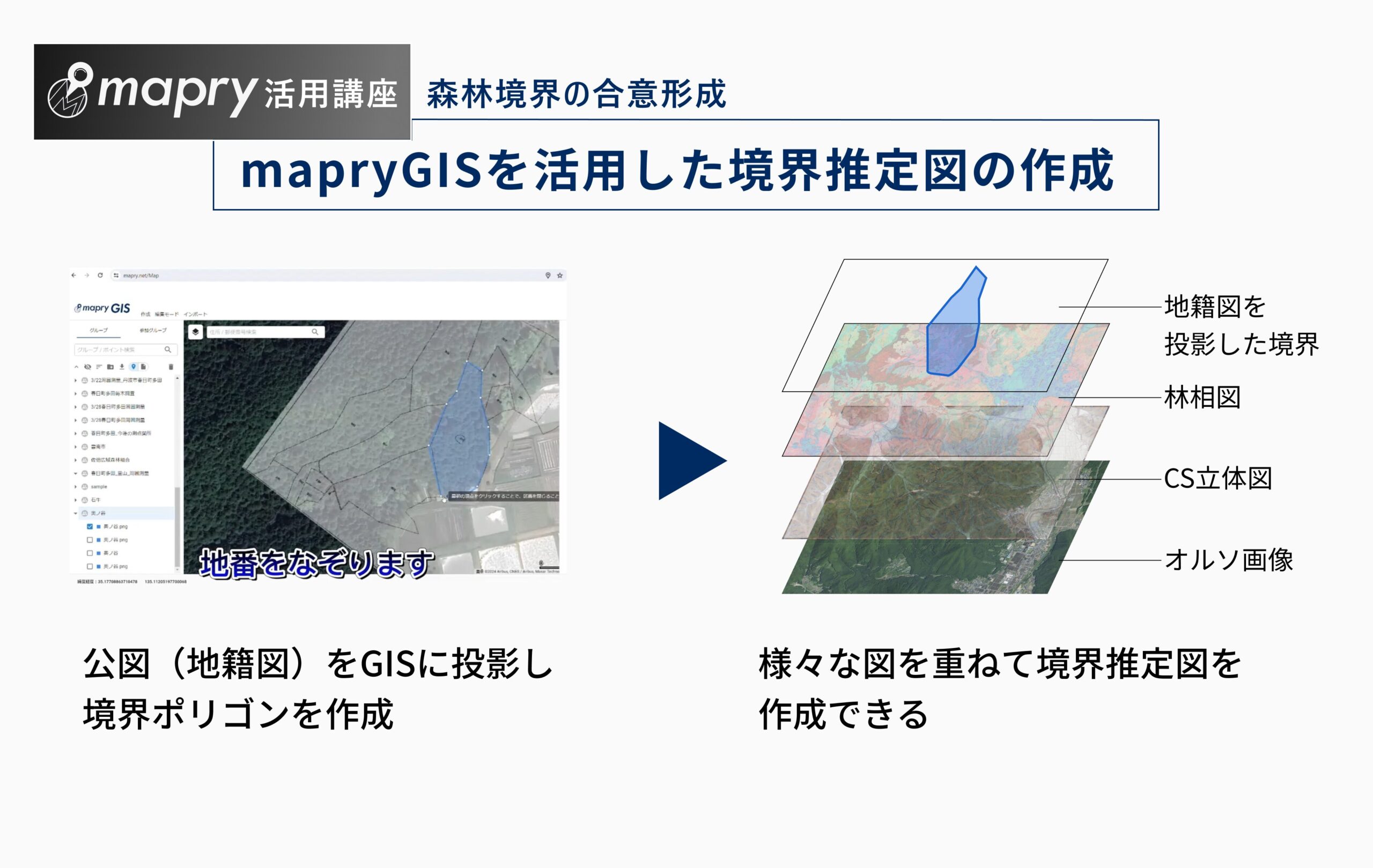
■Using the WebGIS “mapryGIS”
Using mapryGIS, cadastral maps can be projected onto the GIS. Taking advantage of the characteristics of GIS, boundary estimates can be made by overlaying orthoimages, microtopographical representation maps, tree species polygons, etc.
In addition, when explaining to forest owners, you can smoothly reach an agreement by showing them local photos linked to the GIS (standing trees and streams that serve as boundary markers, etc.).
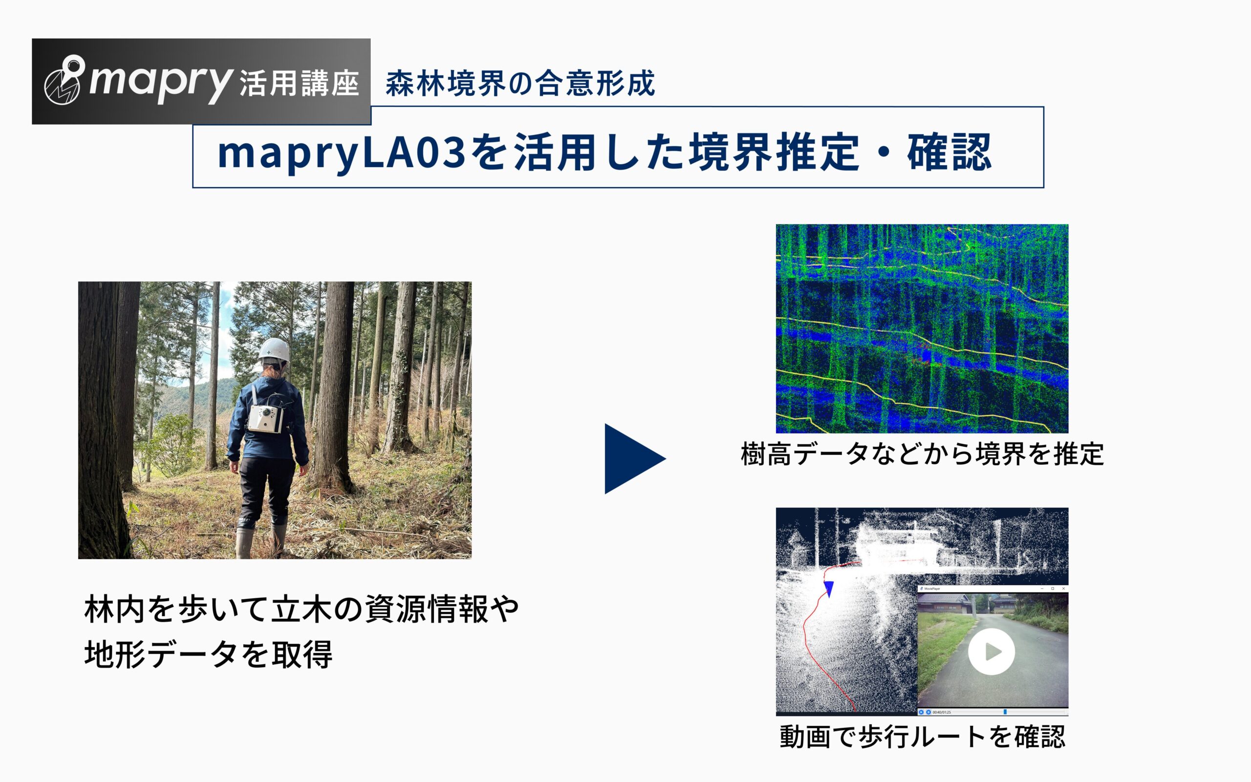
■Using the walking LiDAR “mapryLA03”
If it is difficult to estimate the boundary even after reading official maps, orthoimages, microtopographical representation maps, etc., it is necessary to use remote sensing data to read the differences in tree species and planting times. That’s where mapryLA03, a LiDAR device that can analyze resource information on standing trees just by walking through the forest, comes in handy.
You can read tree height distribution maps and topographical data acquired by mapryLA03 and use them to estimate boundaries. You can also check video data of the route you walked, so please use it for visual boundary confirmation and desk-based consensus building.
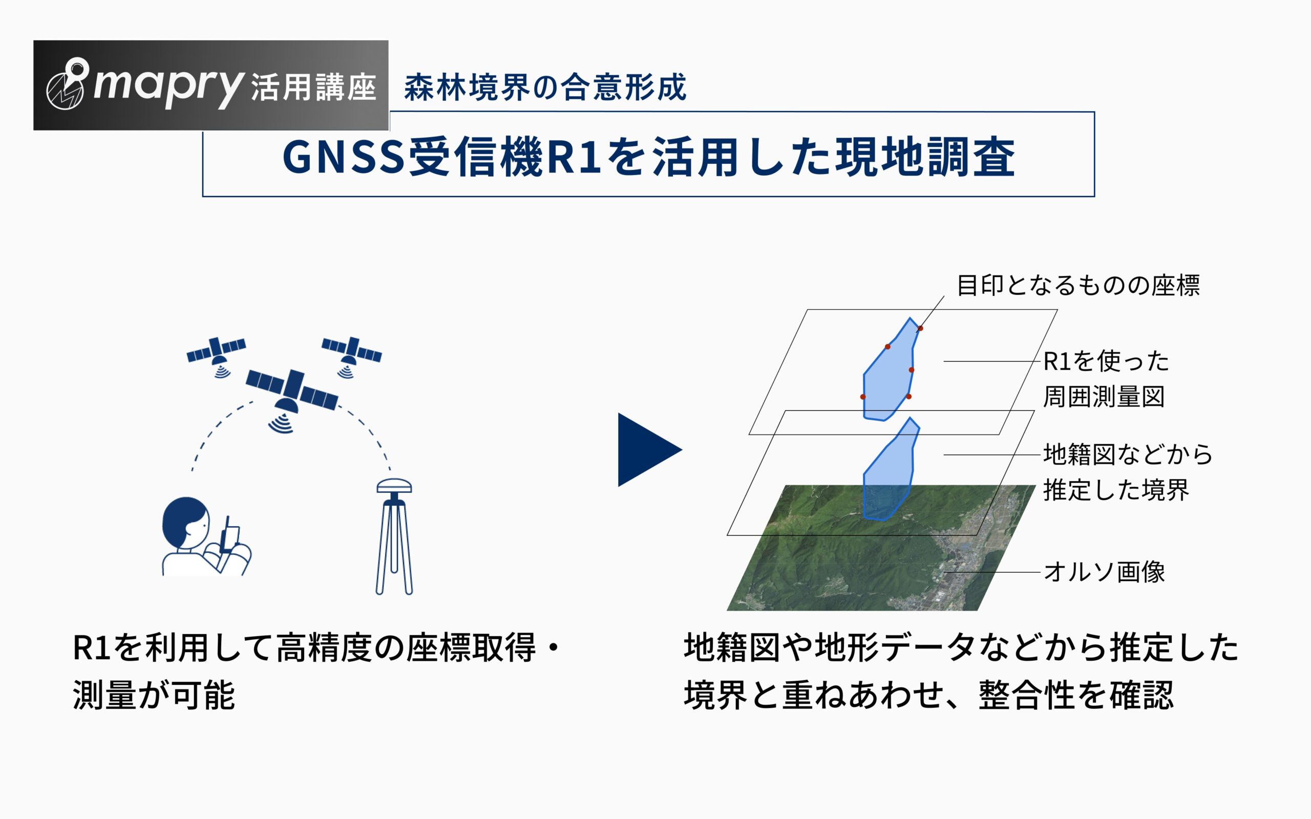
■Using the GNSS receiver “R1”
The “R1” is a GNSS receiver that uses an iPhone/iPad and delivers the same performance as previous surveying equipment. It can be used for field surveys to compare the created boundary estimate map with the local situation. You can record the coordinate values of boundary references (standing trees and streams) and conduct advanced boundary surveys. Please use it in conjunction with the smartphone app “mapry Forestry”.
■Service details
<Smartphone app>
●mapry Forestry
This app is specialized for forestry and forest management, allowing you to easily conduct tree-by-tree surveys, work road completion shapes, and surrounding surveys.
Usage price: 11,000 yen per year (tax included)
<Optional equipment>
●R1
A high-precision GNSS receiver using network RTK. It achieves the same performance as previous surveying equipment on iPhone/iPad.
Sales price: 101,200 yen (tax included)
<WebGIS>
●mapryGIS
A WebGIS that can be linked with apps such as mapry forestry to input and output various files such as drawings and measurement data, output reports, and view point cloud data. If you use a paid account such as mapry forestry (with some exceptions), you can use mapryGIS for free.
■Application for use
https://mapry.jp/contact/
■Company overview
Company name: Mapry Co., Ltd.
Location: 165 Tada, Kasuga-cho, Tamba-shi, Hyogo Prefecture (head office)
Representative: Representative Director Keiji Yamaguchi
HP: https://mapry.jp
Inquiries regarding this matter: info@mapry.co.jp