News
お知らせ
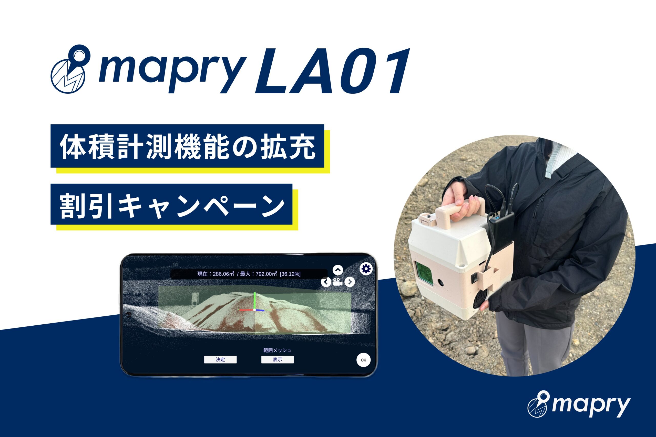
mapryLA01 expands volume measurement function for construction soil, materials, and stockyards
Mapry Inc. (Headquarters: Tamba City, Hyogo Prefecture, CEO: Keiji Yamaguchi, hereinafter referred to as Mapry), which provides the geospatial information app platform service “mapry,” has expanded the volume measurement function of the LiDAR device “LA01” to make it easier to use in construction material management sites such as stockyards. In conjunction with the expansion of functions, a campaign is being held in which the unit price is discounted and the first month’s usage fee is free.
With this update, end-of-month inventory management, which was previously done manually on-site, can now be measured with a smartphone and LA01, and highly accurate volume can be easily calculated from point cloud data.
Please use it in the following situations.
・Management of raw materials and materials such as concrete, cement, and coal
・Management of construction waste soil
・Volume measurement of industrial waste, etc.
・Measurement of soil pits
■About “LA01”
mapryLA01 is a LiDAR device that is ideal for surveying civil engineering sites and acquiring data on the ground. You can switch between capturing point clouds while moving and capturing them while fixed, and can measure up to 200m away. You can survey objects that cannot be approached, such as disaster areas, from a safe location. In addition to fixed-point installation, you can also measure handheld or in-vehicle. It is characterized by its high performance and low price (see the price column for details).
●Update information
The volume measurement function that was previously available has been expanded with functions such as setting the ground level (height of the ground surface) and adjusted to make it easier to use on-site. It can measure the volume of concrete raw materials and construction waste soil. Also, unlike previous devices, it can be used in environments with roofs or where GPS cannot be captured. (*Measurements must be made at a distance of 2-3m or more from the object)
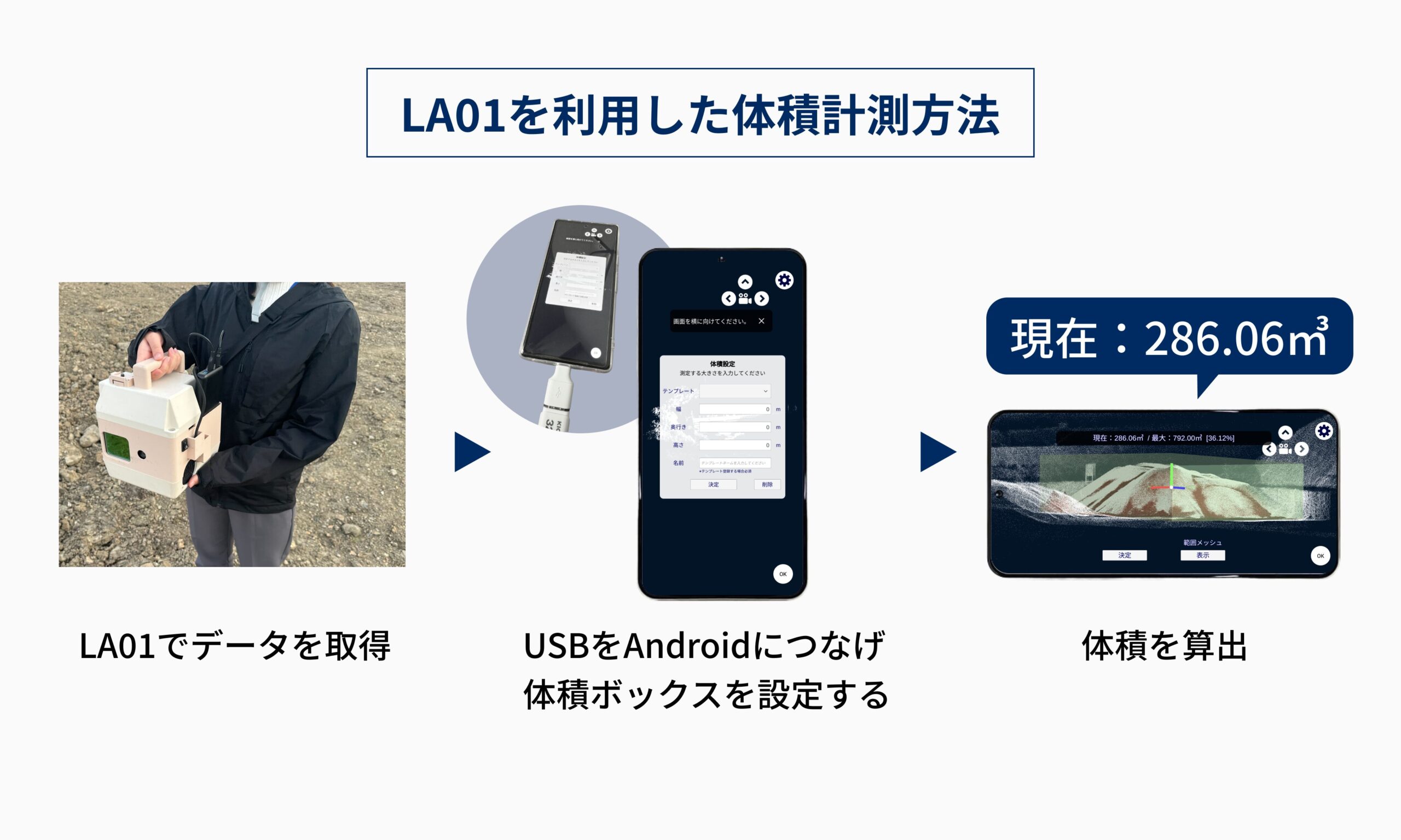
●Volume measurement method
1. Hold the mapryLA01 and move around the object to be measured to scan (at a normal walking speed), and save the data to a USB.
2. Connect the USB to Android and read it.
3. Set the volume box. (Set the width, depth, and height of the object to be measured)
4. Set the ground level. (3-tap)
5. The volume will be displayed.
■Price
<Discount campaign>
Apply between Monday, April 22, 2024 and Friday, May 10, 2024 to receive a 25,000 yen discount (365,200 yen including tax) + first month free (no monthly discount) for the LA01 unit.
*Ends as soon as stock runs out
Normal unit price: 392,700 yen (including tax)
Monthly fee: 11,000 yen (including tax)
■Application link
https://mapry.jp/contact/
■Webinar announcement
We will be holding a webinar (online seminar) to explain the volume measurement and utilization of construction waste soil, materials, and stockyard materials using point cloud data acquired by the LA01. Please apply.
Date and time: Tuesday, May 7, 2024, 17:00-17:30
Content: ・Explanation on how to use mapry (20 minutes)
・Question and answer session (10 minutes)
Fee: Free
Application: Apply here
■About Mapry
Mapry is a service for everyone involved in surveying, forestry, disaster prevention, agriculture, and construction. We provide solutions that make it easy to acquire, analyze, and utilize three-dimensional data, which has previously been difficult to acquire, analyze, and use due to the cost of surveying equipment and the difficulty of operating and analyzing the equipment.
■Company overview
Company name: Mapry Co., Ltd.
Location: 165 Tada, Kasuga-cho, Tamba-shi, Hyogo Prefecture (Head office)
Representative: Representative Director Keiji Yamaguchi
HP: https://mapry.jp
Inquiries regarding this matter: info@mapry.co.jp